Tuesday, August 9, 2011

Thurs Aug 4, 2011. Flathead River, Big Fork, MT


We stopped to visit our Big Fork family and were treated to an evening boat cruise along the Flathead River.  Even Guinness got to take in the sun and mountain scenery!  Thanks to them for great food, showers (yes, there’s a theme on this trip), and fun!
Never thought I'd be on a boat!
Posing bald eagle
Flapping in the breeze!


Wednesday, August 3, 2011

Mon Aug 1, 2011. Jenny Lake, Tetons; Jackson, WY


Rain, rain, and more rain.  We woke up periodically to the sound of rain hitting the roof of the tent and all of us (dog included) chose to hit the snooze button.  When we finally couldn’t hold bladders any more, we got out of the tent to swamp foot – a small lake had formed outside our tent!  A steady rain continued, so we went on a driving tour south through the park to Jenny Lake. 
Jenny lake reminded me of a Switzerland/Glacier Park like view.  One side of the lake was met by towering, glacier covered peaks with waterfalls flowing down into the lake.  It was quite a sight and would have been even more remarkable had clouds not covered the upper half of the mountains.  We had to remind ourselves that the blue sky – snow capped mountain vistas known of the Tetons were just one side of the story: we were “lucky” enough to witness the cloudy, rain filled mountains.
Cloud covered Mount Moran

Jenny Lake on a stormy day
Since we wanted to spend some touring Jackson, WY anyway, we decided to take our rain day into town.  Many of the art galleries welcomed us, even though we were lacking showers and were clearly not capable of a significant purchase.  One of my favorite artists (again, per Chelli and Loren) Carol Hagan (http://www.carolhaganstudios.com/chhomer2.html) from Montana was well-represented in one of the galleries.  The bright colors and impressionist take on grizzlies and other wildlife brings nature to life in a new way.  Some day we’ll be back for your grizzlies, Carol!
A food review: happy hour (2-1s at the Cadillac bar) and burgers from Billy’s next door.  The 1/2 pounders they serve up with waffle fries are a deal!  The line at Billy’s was out the door around lunch time, but we went back in the evening, found a seat in the Cadillac Lounge, and ordered burgers. 
We thought we’d spent enough time in Jackson and headed back “home” to our tent at Colter Bay.  Of course, right as we hit the Teton National Park entrance, the rain started up again – just as we’d left it in the morning.  Another wet night was in our sights.  The washers and driers in Missoula, MT are in for a serious work out!

Sun July 31, 2011. Grand Tetons; Lost Lake, Bridger-Teton National Forest; Grizzlies!


We woke up to a relaxing morning in the Tetons, and hit some of the major vistas in Grand Teton, namely Oxbow Bend, best known for sunrise shots.  Our view was a bit more subdued given the rain clouds overhead.
Oxbow Bend


After a pizza lunch at Leek’s Marina, we picked Guinness up and headed to the Bridger-Teton National Forest for some dog-friendly hiking. 
The Bridger-Teton National Forest is just east of the park a few miles, but we drove out hwy 26/287 looking for forest road 30020.  Without GPS, the road would be easy to miss: it’s an overgrown dirt road behind a construction staging area (near mile marker 23ish).  We drove up the road – and by drove, I mostly mean crept.  The ruts in the road, probably from years of spring washouts, were deep and decorated with huge boulders.  A 4WD, high suspension vehicle is definitely a must.
We reached a “road closed” sign to the left, which marks the beginning of the Lost Lake trail.  The Lost Lake trail is about a mile in length down a former forest road that is now overgrown with lupine.  The trail was a great place to let Guinness off leash to sniff to her heart’s content.

We were surprised to find Lost Lake surrounded by patches of snow and full of cutthroat trout and whitefish.  The scenery was beautiful, but the mosquitoes were horrendous.  Even with bug dope on, they were swarming us looking for any patch of skin or clothing that was missed by the bug spray.  We didn’t stay at the lake long, but on a bug-free day, this hike would have been a great break from the bustling Tetons.
Lost Lake reflection

On the way back into the Colter Bay campground, we drove up to a 1-car critter jam.  We slowed down and saw a big brown blob slowly making her way along the ditch just on the other side of the road: a huge, healthy, brown grizzly!  As she walked along, now coming parallel to us, two cubs came tagging along behind her from in the brush.  One of the grizzly cubs took a break next to the side of the road.  Sitting back on his behind seeming to check us out with as much excitement and interest as we had in him!  After playing with a few long blades of grass, mamma started calling to him from down below in the gully.  He obliged just as the rangers pulled up with lights flashing to move traffic along and send people back to their cars.  A mamma grizzly with cubs is an animal best left alone to go about her bear-business.


Monday, August 1, 2011

Sat July 30, 2011. Travel day – Evenston, WY to Grand Teton National Park, WY


We finally arrived back in the cool, crisp mountain air!  It always feels like home to drive through the windy mountain roads, coast down the passes, and see snowcapped peaks all around. 
We drove through Jackson, WY on the way to Grand Teton and decided to come back later.  We already had a late start from the Motel 6; multiple rinse, lather, repeat cycles were required to get rid of the Moab layers.  I actually thought my legs had a nice tan.  Turns out my “tan” washed off.  I even had some bruises I didn’t know were there.  Sorry, I digress.
We had hoped to camp at the popular Jenny Lake campground in the Tetons.  It is tent camping only, near many entry points into the mountains, and farthest south, i.e. closest to Jackson.  It usually fills by 9 am, so we drove farther north and found a site at Colter Bay.
I was skeptical of camping at Colter Bay only because the campground has 350 sites!  But, I was pleasantly surprised to find the sites secluded, surrounded by trees, and amazingly quiet.  We even ended up in a “generator” loop with campers nearby but haven’t heard one yet. 
One downer for the day: had to make a 45 minute drive back to Jackson because our 8 day old Coleman air mattress had a leak!  Ugh!  We made it to the Sports Authority just before closing and picked up a new one. 
One pick up for the day: since we were in Jackson, we decided to check out an art gallery that was still open (per Chelli’s recommendation).  It was phenomenal!  We got a little tour of the various artists represented there, since we were the only ones that late at night.  The gallery guy told us many stories about real estate in the area, the beginning of the National Park, and of course, we talked art.  What a relaxing and fun way to wrap up an evening that we had been irritated about.  Just goes to show, when on vacation (or anytime, really), take what’s handed to you and make the best of it!

Fri July 29, 2011. Negro Bill Canyon Trail; Travel day to Wyoming


If you’re looking for a cool, shady hike (in relative desert terms, of course) with incredible scenery, the Negro Bill Canyon Trail just outside of Arches is a must do.  Just off of hwy 128 on the way to many of the campgrounds along The Colorado, is the turnoff for a 2.5 mile hike along an ever flowing stream.
The trail meanders along the stream, crossing it at several points, allowing dogs and people the chance to cool off.  With only a 330 foot elevation gain, most of which is near the end of the trail, almost anyone can walk to the highlight of the trail: Morning Glory Arch.


Morning Glory Arch is the 6th largest rock span in the U.S. at 243 feet in length and is a hidden gem in the Arches National Park area.  Although the trailhead was full of cars – many of them from a rock climbing adventure group – people were spread out enough along the vegetation-covered trail that we took in some much-needed time away from the crowds of Arches.


After hiking in the morning, we got back to the car full of sweat and dirt again to find the temperature had reached 95 degrees before noon.  Yikes!  Before leaving Moab for Wyoming, we stopped by Lin Ottinger’s rock and fossil shop (www.moabrockshop.com) and had lunch at the Moab Brewery. 
A few notes on these places: Lin’s is slightly overpriced, although we were admittedly in a tourist town.  That being said, he is a well-known dinosaur fossil hunter, has a museum collection in his shop, and has a vast selection.  There were a few things I would have liked on my bookcase if it weren’t for the price.  Maybe we’ll be back in a few years.
Second, the Moab Brewery has good food at good prices, although the beer leaves a bit to be desired.  We tried the pale ale and thought it wasn’t well balanced with aroma hops that are usually added at the end of the brewing process.  The Pilsner was a better choice.  The best thing on the menu at the Moab Brewery has to be the beer cheese soup.  Order a side of this if you have anything with french fries and sub for ketchup.  Or, just eat bowls and bowls of this soup.  It tasted like a queso deliciously thinned out to soup consistency with beer.  I’m actually drooling a bit right now just thinking about it.  I seriously thought of asking whether I could get an ice cream bucket of it to go.  In retrospect, I really should have done that.  If anyone happens to be at the Moab Brewery, drop me a line and I’ll send you postage and pay for the beer cheese soup if you send me a shipment of it.
We left the dry, hot, sandy desert for the cool mountains and spent the night halfway just across the border of Utah and Wyoming at the Motel 6 in Evenston, WY.  One more night out of eating took us to Michael’s bar and grill.  We found it, oddly enough, by google reviews even though Michael’s doesn’t have its own website.  Echoing the other reviews, Michael’s has great sandwiches, good prices, and some of the best service around.   If you ever find yourself in Evenston, WY, don’t stay too long but do try out Michael’s.

Thurs July 28, 2011. Landscape Arch, Arches; Deadhorse Point State Park; Canyonland National Park


To avoid the crowds and “Disneyland-like” feel of Arches, we got up early, skipped coffee and headed straight for one of the iconic arches in the park: Landscape Arch.  Landscape is accessible by a short walk (~1 mile) and is best seen in the morning.  We arrived before 8:00 and found the parking lot at the trailhead about half full. 
Landscape Arch is truly impressive.  At over 3 football fields in length, it is one of the longest natural arches, but it is also one of the thinnest.  In the 70s, park visitors actually happened to be picnicking beneath the arch when they heard rumbling, looked up, and saw a few pebbles falling from the arch.  Moments later a huge, 70 ton slab of rock fell from the arch, narrowing it even further.  Because of this, the trail now stays in front of the arch.  Ironically, the same force that initially formed the arches: the falling of rock, will eventually lead to its demise.  The latter can be seen in action at Landscape Arch.  Truth be told, we did put the video on for a few seconds wondering if we might be the next to capture a fall.  

Arches shares a great mesa with other rocky lands that have been affected by water and erosion over millennia.  Because of differing rock composition and the action of two rivers: The Colorado and The Green, a vast canyon formed and was protected as Canyonlands National Park. 
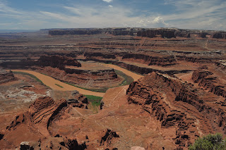
Canyonlands can be seen in the distance from Dead Horse State Park, which overlooks a sharp bend in The Colorado.  Dead Horse Point has become a bit of a mecca for photographers in the past few years, and improvements to park facilities from the increase in $10 entrance fees are apparent.
The view from Dead Horse Point is impressive as it overlooks the river bend and the expansive Canyonland National Park extends out toward the horizon.  Normally, The Colorado runs green, making for a beautiful contrast of colors against the red rock walls.  But, we visited during monsoon season and the daily, heavy rains had turned the Colorado brownish-red.  Although the view at Dead Horse Point is beautiful, if one had limited time, bypassing this small state park for the vastness of Canyonlands itself would be a good choice.

Canyonlands, like Grand Canyon National Park, has a road that drives along the rim with many turnouts offering views across the canyon.  Also similar to Grand Canyon, the vastness of Canyonlands is hard to take in by eye. 
The LaSal Mountains with an afternoon rainstorm 31 miles past the canyon

Saturday, July 30, 2011

Petroglyphs and Pictographs of the American Southwest


After being skunked on the Hidden Valley Trail near Moab, UT, I asked an Arches Park Ranger for some advice on ancient rock art in the area.  It turns out there are a number of sites that can be visited by car right in Moab.
Prehistoric and historic peoples (Paleo-Indians) inhabited the American southwest and were primarily large game hunters.  They left records of their existence on black rock faces, called desert varnish, seemingly a form of visible time capsule.  A glimpse into their lives shows similar animals that are seen in the area today: big horn sheep, snakes, deer, and similar landscape markers: river routes.


Later (1300-1880 AD), Ute Indians left their marks on boulders and cliff faces, often overlaying their petroglyphs over those from previous cultures.  These can be identified by the presence of horse and rider images, indicative of the Spanish introduction of horses in the 1500s.
On our way north to Wyoming, we stopped at the Sego Canyon Petroglyphs based on a tip from our 1990s Statefarm atlas.  We were pleasantly surprised to find large petroglyph images from the Barrier Canyon period created by people who inhabited the area between 8,000 and 2,000 years ago.  These are truly amazing piees of history, but it was disheartening to see vandalism by those who chose to leave their modern marks on the same rock faces.  
Around the corner from these first images are a set of pictographs.  Pictographs differ from petroglyphs in that they are painted on rather than carved into rocks. Check out Kathy Weiser’s excellent information about the history of Sego Canyon, UT (http://www.legendsofamerica.com/ut-segocanyon.html).


Friday, July 29, 2011

Wed July 27, 2011. Hidden Valley Trail and Arches Sunset


Since dogs aren’t allowed on Arches National Park trails and the park hosts 1 million visitors each year (approximately ½ of which seem to be there right now...), we decided to try a hike outside the park. 
Hidden Valley Trail is just 3 miles south of Moab on 191.  The trail gains 680 feet in elevation quickly through switchbacks over large red and tan boulders (nicknamed Barney Rubble).  Even though we started in the morning, the trail was already burning up and Guinness was wishing she hadn’t worn her black coat.  
Nearing the top of the switchback trail

Once we reached the top, the trail flattens out and meanders through a hot, dry valley flanked by high rocky cliffs.  Others have described seeing petroglyphs on this trail, but even though we had binoculars out and scoured some rocks along the trail, we weren’t lucky enough to see any.  We found shade underneath some scattered Juniper trees and overhanging rocks before heading back down the sun-baked switchbacks.
Hidden Valley
 We decided to head back to camp along the CO river to cool off – if that’s possible in the desert – and to try Arches for some sunset pictures.  It turned out we weren’t the only ones with sunset pictures on the agenda.  We headed toward Turret Arch and The Windows but were disappointed to be greeted by a desert rainstorm.  We waited it out and the clouds began to break up. 


The rain ended, the clouds blew over, and the sunset light was truly phenomenal.  We found a perch behind Turret Arch with a view of The Windows if we climbed high enough.  The few pictures we were able to snap without the .5 million other visitors happened in a window of about 2 milliseconds.  In all seriousness though, there was a very good reason we weren’t the only ones enjoying the soft evening light reflecting off of the red arches.
Turret Arch from below with one of The Windows in the distance


Thursday, July 28, 2011

Tues July 26, 2011. Travel Day – Blue Lakes to Arches National Park via Telluride, CO.


The morning was damp, but the rain had stopped and we were able to dry out a bit before packing up.  The hike down from Blue Lakes was quick, and the flip flops and wet wipe bath were much appreciated upon reaching the car! 
We drove to Telluride, CO for lunch and to regroup.  Telluride is tucked into a valley with a waterfall flowing down from the mountaintop almost as if the city council installed a pump to keep it flowing down toward the town.  We had lunch at Smugglers.  Note: good food, but don’t upgrade a sandwich to a “basket.”  A basket means add a shot glass of coleslaw and ~10-12 french fries for $2.
Our first (and, knock on wood, only) car trouble happened: we noticed a back tire wasn’t holding pressure.  Finally found the Telluride Tire and Auto center and $25 and a patch later, had 2 screws to our names. 
The rain from Blue Lakes had followed us down and we made our way toward drier country in southern Utah.  Along the 141 from Telluride, the rain fell farily hard.  Brownish-red flash floods covered the road periodically from the Sedona-like red rock cliffs above us.  The red rocks gradually became drier and we pulled into Moab, UT on our way to Arches National Park. 
Mesa along UT 90 just outside of CO

Arches only has 52 campsites that are reservable, i.e. full during the summer months.  Luckily, there are a number of public campgrounds on UT 128 directly along the Colorado River.  We were surprised to find the campsites relatively secluded with scrub oak, brush, and small trees separating them.  We settled in for the night, feeling lucky to be back on a queen size air mattress instead of backpacking pads!

Mon July 25, 2011. Blue Lakes Pass


Crisp mountain air greeted us as we awoke to a clear blue Colorado sky.  We enjoyed Starbucks instant coffee (yes, a bit fancy for the backcountry, but as Bear Grills would say: a great morale booster to have a “creature comfort.”) and Cliff bars to fuel ourselves for a day hike along the Blue Lakes chain, up the pass toward Sneffels, and a possible summit.
We made our way above Lower Blue after a few switchbacks and just 20 minutes.  The hike was significantly easier than the day before without the weight of backpacks and with the aid of another night of acclimatizing!  The wildflowers above Lower Blue were equally as impressive as lakeside.  They seemed to blanket the entire mountainside and provided a foreground that complemented the blue waters below and the gray mountains above.


Continuing on the trail lead us above the tree line and next to Middle Blue Lake, which was also flanked by columbines.  The switchbacks toward the Blue Lakes pass at 13,000 feet finally came into view and made me question whether we’d make it.  A little farther along and a stream crossing later, we were above Upper Blue Lake and the basin began to roll out beneath us as we climbed higher toward the pass.
Middle Blue Lake

Upper Blue Lake looking north with the pass behind us

The switchbacks up to Blue Lakes Pass begin in a wildflower area, this time filled with yellows and whites.  Once out of the wildflowers, the trail narrows.  Some places had been washed out making for an anxious mom as I held tight to the coonhound’s leash hoping she would stay close behind me.  It turns out she has a version of 4 wheel drive that made her steadier than I!
We reached the pass around noon with Sneffels now above us to the left looking near enough to summit.  But, dark clouds were thickening around us and the southwest sky looked ready to burst.  We snapped some pictures in both directions and decided Sneffels would have to wait for another trip.
Blue Lakes from the pass at 13,000 feet
Looking south into the San Juans from the pass - note the parking lot to the left!
As we headed back down the pass, big, cold raindrops started falling followed closely by pea-sized hail.  We stopped to put on raingear and met a few hikers still trying to reach the pass.  They were undeterred by the storm, but we were concerned enough about lightening and the cold rain that we hurried through the switchbacks to a lower elevation.  The wind picked up and blew rain and hail sideways into us.  Even reaching the tree line didn’t provide much respite.
When we finally made it to the tent, Guinness was soaked to the bone and shivering.  In 4 years, I’ve never seen her shiver.  I dried her off and wrapped her in my down sleeping bag in the tent.  She warmed quickly enough, but it was a good reminder about the need to stay dry in the mountains and to find shelter when it’s needed.
A steady rain shower continued into the evening, and we heard immense rockslides nearby, likely caused by melting snow.  We went down to the lake to get a clear view of the basin but couldn’t see any danger – namely above our campsite.  As others before us, I had a sense of being an uninvited guest in a wild, yet peaceful place.  Nature was continuing on despite our presence.  We were quiet bystanders in a place that goes on with or without (perhaps better in the latter case) human guests.

Sun July 24, 2011. Blue Lakes Trail, Uncompahgre National Forest & Mt. Sneffels Wilderness, CO


After a late morning start out of Montrose, we drove south toward Ridgway, CO.  From Ridgway, head west on 62, then south on 7 to the Blue Lakes Trailhead (stay on 7 after the split with 7a).  7 is a dirt road that winds through cattle country with stunning views of the looming Colorado 14er, Mt. Sneffels, in the distance.  
Mt. Sneffels with the Blue Lakes tucked in to the right

We arrived at the trailhead (a.k.a. Walmart parking lot) and had to park on a side road.  It turns out that day hikers frequent this trail, and most of the folks and dogs we met were coming back around 12:30.
 
The trail from the north side starts at 9,400 ft and switchbacks its way along Dallas Creek.  Most of the trail is through wooded areas providing a welcome break from the near sun.  One stream crossing was aided by trekking poles, but could have been forded relatively easily without them.  1,500 vertical feet and a little over 3 miles later, we arrived at Lower Blue Lake, which truly does live up to its name.  


Lower Blue was surrounded by wildflowers: columbine, lupine, Indian paintbrush, bluebells, and many other shades of yellows, whites, and pinks.  The sound of waterfalls bringing fresh snowmelt into the lake and the outflow down Dallas Creek were the only things we could hear, despite the presence of a few remaining dayhikers and one other backpacking group.  We spent the remaining daylight hours taking it all in and watching a content coonhound explore the water’s edge.


Note: helpful items to take backpacking, especially to the East Dallas Creek drainage include head lamps or other light source, books, playing cards – no campfires are allowed in this area.  Also, organizing backpacking gear somewhere other than a Motel 6 parking lot may aid in the ability to remember these items...

Wednesday, July 27, 2011

Sat July 23, 2011: Travel day – Dillon, CO to Southwest CO

En route to the San Juan Mountains of southern Colorado, we decided to find a hotel room in Montrose.  Wouldn’t you know, there was a rodeo in town?!?  Likely found the last room in town at the Motel 6 and then headed to our first national park of the trip: Black Canyon of the Gunnison (BCotG).

Driving to BCotG reminded me a lot of heading toward the Grand Canyon, except there was a lot more terrain.  It was similar in that we were seemingly driving along, enjoying the wilderness, and BAM!, a huge gorge opens up in the landscape that is hard to take in by eye.  The BCotG was eroded by the Gunnison River, which has the same vertical drop as the Mississippi River but in merely a ~20 mile section.  The river cut through the canyon so rapidly that erosion did not have time to widen the canyon and is reflected in the sharp, steep walls rising up to 2,000 feet in places.

After cruising the rim, we traveled down to the canyon floor following a dirt road, many switchbacks, and a 16% grade – no, Shana, you can’t go on that road.  It was serious enough that I didn’t have it in neutral.  The Gunnison River in this stretch contains Class 4+ rapids that have been known to take lives.  We made our way back out of the canyon and thanked Ol’ Blue for getting us down and back.

Drove back to the Motel 6 for possibly the best shower of my life, a cold beer, and a good night’s rest.